
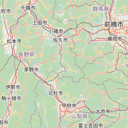
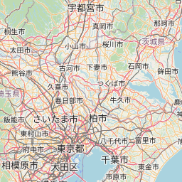
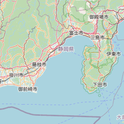
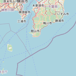
坂東三十三箇所巡礼マップ
= 関東1都6県、33か所の観音霊場 = |
 |
《坂東三十三箇所》
一 杉本寺 二 岩殿寺 三 田代寺 四 長谷寺 五 勝福寺 六 長谷寺 七 光明寺 八 星谷寺 九 慈光寺 十 正法寺 十一 安楽寺 十二 慈恩寺 十三 浅草寺 十四 弘明寺 十五 長谷寺 十六 水澤寺 十七 満願寺 十八 中禅寺 十九 大谷寺 二十 西明寺 二十一 日輪寺 二十二 佐竹寺 二十三 観世音寺 二十四 楽法寺 二十五 大御堂 二十六 清瀧寺 二十七 円福寺 二十八 龍正院 二十九 千葉寺 三十 高蔵寺 三十一 笠森寺 三十二 清水寺 三十三 那古寺
一 杉本寺 二 岩殿寺 三 田代寺 四 長谷寺 五 勝福寺 六 長谷寺 七 光明寺 八 星谷寺 九 慈光寺 十 正法寺 十一 安楽寺 十二 慈恩寺 十三 浅草寺 十四 弘明寺 十五 長谷寺 十六 水澤寺 十七 満願寺 十八 中禅寺 十九 大谷寺 二十 西明寺 二十一 日輪寺 二十二 佐竹寺 二十三 観世音寺 二十四 楽法寺 二十五 大御堂 二十六 清瀧寺 二十七 円福寺 二十八 龍正院 二十九 千葉寺 三十 高蔵寺 三十一 笠森寺 三十二 清水寺 三十三 那古寺


地図について(出典など)
- 当サイトでは、国土地理院が提供する「地理院タイル」や、「OpenStreetMap」などを使用しています。ご利用に当たっては「地理院コンテンツ利用規約」「OpenStreetMap」などをご覧ください。それぞれの地図は、表示される縮尺が限られるもの、地域が限定されるものなどがあります。ここでは、地図の利用に当たって出典の明示が義務づけられているものの内、地図上に表示されるもの以外の出典、および凡例などを示します。このお知らせは、地理院タイルを利用する全てのページにおける共通のものであり、現在のページにおいて下記の地図の全てが表示されるとは限りません。
- ズームレベル 5~8:「The bathymetric contours are derived from those contained within the GEBCO Digital Atlas, published by the BODC on behalf of IOC and IHO (2003) (http://www.gebco.net)
海上保安庁許可第292502号(水路業務法第25条に基づく類似刊行物)」 - Shoreline data is derived from: United States. National Imagery and Mapping Agency. "Vector Map Level 0 (VMAP0)." Bethesda, MD: Denver, CO: The Agency; USGS Information Services, 1997.
- ズームレベル 5~8:Shoreline data is derived from: United States. National Imagery and Mapping Agency. "Vector Map Level 0 (VMAP0)." Bethesda, MD: Denver, CO: The Agency; USGS Information Services, 1997.
- ズームレベル 2~8:Shoreline data is derived from: United States. National Imagery and Mapping Agency. "Vector Map Level 0 (VMAP0)." Bethesda, MD: Denver, CO: The Agency; USGS Information Services, 1997.
- ズームレベル 5~8:「The bathymetric contours are derived from those contained within the GEBCO Digital Atlas, published by the BODC on behalf of IOC and IHO (2003) (http://www.gebco.net)
海上保安庁許可第292502号(水路業務法第25条に基づく類似刊行物)」
Shoreline data is derived from: United States. National Imagery and Mapping Agency. "Vector Map Level 0 (VMAP0)." Bethesda, MD: Denver, CO: The Agency; USGS Information Services, 1997. - Geospatil Information Authority of Japan (GSI)
《地理院写真》- ズームレベル 9~13:Landsat8画像(GSI,TSIC,GEO Grid/AIST), Landsat8画像(courtesy of the U.S. Geological Survey), 海底地形(GEBCO)
- ズームレベル 2~8:Images on 世界衛星モザイク画像 obtained from site https://lpdaac.usgs.gov/data_access maintained by the NASA Land Processes Distributed Active Archive Center (LP DAAC), USGS/Earth Resources Observation and Science (EROS) Center, Sioux Falls, South Dakota, (Year). Source of image data product.
《地理院色別標高図》ズームレベル 5~15- 海域部は海上保安庁海洋情報部の資料を使用して作成.
- ズームレベル 5~8:「The bathymetric contours are derived from those contained within the GEBCO Digital Atlas, published by the BODC on behalf of IOC and IHO (2003) (http://www.gebco.net)
スポンサーリンク
スポンサーリンク
おすすめサイト・関連サイト…
スポンサーリンク