
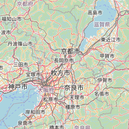
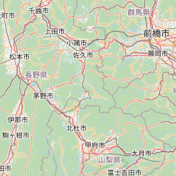
西国三十三箇所巡礼マップ
= 大阪府内の観音霊場 = |
 |


地図について(出典など)
- 当サイトでは、国土地理院が提供する「地理院タイル」や、「OpenStreetMap」などを使用しています。ご利用に当たっては「地理院コンテンツ利用規約」「OpenStreetMap」などをご覧ください。それぞれの地図は、表示される縮尺が限られるもの、地域が限定されるものなどがあります。ここでは、地図の利用に当たって出典の明示が義務づけられているものの内、地図上に表示されるもの以外の出典、および凡例などを示します。このお知らせは、地理院タイルを利用する全てのページにおける共通のものであり、現在のページにおいて下記の地図の全てが表示されるとは限りません。
- ズームレベル 5~8:「The bathymetric contours are derived from those contained within the GEBCO Digital Atlas, published by the BODC on behalf of IOC and IHO (2003) (http://www.gebco.net)
海上保安庁許可第292502号(水路業務法第25条に基づく類似刊行物)」 - Shoreline data is derived from: United States. National Imagery and Mapping Agency. "Vector Map Level 0 (VMAP0)." Bethesda, MD: Denver, CO: The Agency; USGS Information Services, 1997.
- ズームレベル 5~8:Shoreline data is derived from: United States. National Imagery and Mapping Agency. "Vector Map Level 0 (VMAP0)." Bethesda, MD: Denver, CO: The Agency; USGS Information Services, 1997.
- ズームレベル 2~8:Shoreline data is derived from: United States. National Imagery and Mapping Agency. "Vector Map Level 0 (VMAP0)." Bethesda, MD: Denver, CO: The Agency; USGS Information Services, 1997.
- ズームレベル 5~8:「The bathymetric contours are derived from those contained within the GEBCO Digital Atlas, published by the BODC on behalf of IOC and IHO (2003) (http://www.gebco.net)
海上保安庁許可第292502号(水路業務法第25条に基づく類似刊行物)」
Shoreline data is derived from: United States. National Imagery and Mapping Agency. "Vector Map Level 0 (VMAP0)." Bethesda, MD: Denver, CO: The Agency; USGS Information Services, 1997. - Geospatil Information Authority of Japan (GSI)
《地理院写真》- ズームレベル 9~13:Landsat8画像(GSI,TSIC,GEO Grid/AIST), Landsat8画像(courtesy of the U.S. Geological Survey), 海底地形(GEBCO)
- ズームレベル 2~8:Images on 世界衛星モザイク画像 obtained from site https://lpdaac.usgs.gov/data_access maintained by the NASA Land Processes Distributed Active Archive Center (LP DAAC), USGS/Earth Resources Observation and Science (EROS) Center, Sioux Falls, South Dakota, (Year). Source of image data product.
《地理院色別標高図》ズームレベル 5~15- 海域部は海上保安庁海洋情報部の資料を使用して作成.
- ズームレベル 5~8:「The bathymetric contours are derived from those contained within the GEBCO Digital Atlas, published by the BODC on behalf of IOC and IHO (2003) (http://www.gebco.net)
スポンサーリンク
スポンサーリンク
おすすめサイト・関連サイト…
スポンサーリンク